Long description: fig7
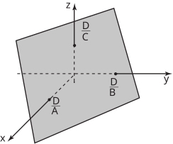
Alt text: A three-dimensional coordinate system with an inclined plane labeled with various dimensions.
This description was generated by AI and has not been verified by a human. If you spot an error, please use the feedback link below.
- The image displays a diagram in a three-dimensional Cartesian coordinate system, featuring axes labeled as \(x\), \(y\), and \(z\).
- There is a shaded, planar surface that is tilted relative to the \(x\)-\(y\) plane.
- Several dashed lines and labels indicate dimensions across this plane:
- The horizontal axis represents the \(x\)-direction.
- The axis extending into the page represents the \(y\)-direction.
- The vertical axis represents the \(z\)-direction.
- Dimensions are labeled for the projections or spans of the surface in each direction:
- A distance labeled \(\frac{D}{A}\) is shown along the \(x\)-axis direction, indicating a dimension on the lower-left portion of the plane.
- A distance labeled \(\frac{D}{B}\) is shown along the \(y\)-axis direction, indicating a dimension on the upper-right portion of the plane.
- A distance labeled \(\frac{D}{C}\) is shown along the \(z\)-axis direction, indicating a dimension on the upper portion of the plane.